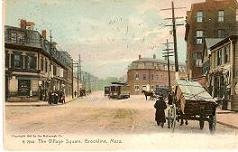
The photo below, taken sometime in the first decade of the 20th century, shows Aspinwall Hill from a vantage point on Corey Hill. (See a supersized version of the photo
here.)
For perspective, note the building with the rounded corner at lower right. It was — and still
is —at the southeast corner of Washington and Beacon Streets. Athan's Bakery occupies the first floor today.
 |
| The Athans Bakery building, then and now |
Several other buildings in the photo are still there today: buildings on Washington Street (just behind the Athan's building) and, successively higher up the hill, on University Road, Winthrop Road, Addington Road, and Colbourne Crescent.
But what was that building with the tower at the top of the hill? It looks like a church or other institutional edifice.
In fact, it was the home of Clarence and Rosamond Esty on Addington Road. The tower, unusual for a private home, was built to take advantage of the house's location at the top of the hill. Here's how the
Boston Post described it in 1913:
Few houses in the world have such a magnificent panorama spread out before them as that of Clarence H. Esty, 97 Addington road, Brookline. This house is situated on the top of a hill, and Mr. Esty has bought up all the land immediately surrounding it, so as to avoid all possibility of the view of which he is so proud becoming obstructed. On the top of the house Mr. Esty has built an observation tower, in which is a powerful telescope. From this point of vantage the whole of Boston lies spread out before one, not to mention all the suburbs and the country to the west.
 |
| Clarence H. Esty |
Clarence Houghton Esty (1854-1917) was born in Ithaca, New York. He earned a law degree from Cornell University, but never practiced. He joined his father and brother in the prosperous leather manufacturing business founded by Clarence's grandfather. Esty married Rosamond Claire Field in 1893 and built the Brookline house for his family in 1897 after retiring from business.
Clarence Esty died in 1917. Rosamond Esty died in 1942. The property was acquired by the Town of Brookline. After demolition of the house it was turned into Addington Park, renamed Schick Park in 1955.
 |
| Schick Park on Addington Road is on the site of the Esty home and observation tower that stood from 1897 until the 1940s. |
NOTE: The Aspinwall Hill photo is one of several photos from the collection of
Warren Manning, former planting supervisor for Frederick Law Olmsted in Brookline. It was taken after Manning left Olmsted to go out on his own. The photos are held by the Iowa State University Library Special Collections and have been reproduced with their permission.
The
building immediately below the tower in the Manning photo is actually across the street from
the Esty house, at 94-98 Addington Road, where it still stands.