Mention “the reservoir” to people in Brookline today and they will probably think of one of two bodies of water: the Chestnut Hill Reservoir or the Brookline Reservoir.

But the Chestnut Hill Reservoir is actually in the Boston part of Chestnut Hill, just over the Brookline border.

And the much older Brookline Reservoir, while in Brookline, was built as part of Boston’s water supply, not Brookline's.

This presentation is not about those reservoirs, but about three other Brookline reservoirs, all on Fisher Hill. These reservoirs no longer exist as bodies of water, but they have left their mark on the landscape and the town.
The map below at left, a portion of an 1855 map of Brookline, shows Fisher Hill at center left, north of the Brookline Reservoir. The map at right shows more or less the same location today.


The older map was made 11 years after the Brookline Reservoir was built as part of the system bringing water from Lake Cochituate through Brookline to Boston.
The New York and Boston Railroad, introduced in 1845, runs through the low-lying valley in the center of the map, between Fisher Hill and Aspinwall Hill.
That, today, is the route of the D branch of the Green Line.
Beacon Street, laid out as a narrow, unpaved country lane in the 1850s, is to the north.
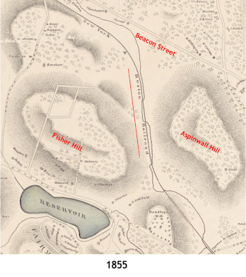
A few streets have been laid out across Fisher Hill, though houses are still largely confined to the lower slopes and would remain so for another 30 years.

By 1874, when the view below (part of a larger map) was produced, Brookline was in the process of building its own reservoir on Fisher Hill to serve the town.

A natural pond, shown in the circle in the center of this view, had been converted into an earthen basin to hold water that could flow through pipes from the high elevation of Fisher Hill to other parts of the town.
 |
The water came from the Charles River, at the Dedham/West Roxbury border, four miles away.
“The Town of Brookline,” reported the Boston Globe, “is now actively engaged in laying down pipes, constructing reservoirs, and setting up the machinery for a supply of water from Charles River.”
“The water is to be raised to an elevated point near the river….whence it will flow by its own gravity to the summit of Fisher's Hill…. 240 feet above tidewater.”
“From this point it is distributed through service pipes to the consumers.”
The pumping station in West Roxbury, shown below, was built on land owned by the Town of Brookline. It sent the Charles River water through through pipes up to Fisher Hill.


In 1888, the City of Boston built the Fisher Hill Reservoir, across Fisher Avenue from Brookline’s reservoir, as part of Boston’s own water supply


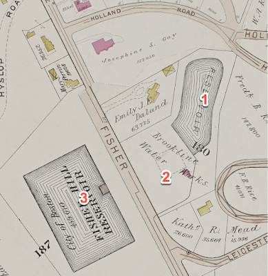
In 1893, Brookline added a second, smaller, covered reservoir to its own water system. It is under the dashed lines, marked “Brookline Water Works," between Fisher Avenue and the town’s older, open reservoir, on the map below.

The trade journal The Engineering Record presented sketches of the unusual covered reservoir.

But to really get a sense what that looked like, here are underground photos from a few years ago, before a new development was built on the site of the long-unused covered reservoir.


By the time of the 1907 map below, the older, open reservoir of the Brookline Water Works had also been covered.

A brick house, owned by Josephine and Frederick Gay, had been built just north of the reservoirs.

This aerial view below, from 2025, shows new housing, outlined in pink, in the area once occupied by the Brookline reservoirs.

Fisher Hill Reservoir Park occupies the space of the former Boston reservoir.
The former Josephine and Frederick Gay house is now Mitton House, named for a later owner and now part of a new senior housing complex called The Newbury at Brookline.
The following views show some of the varied landscapes of today’s Fisher Hill Reservoir Park, opened in 2016…


...along with an historical marker telling the history of the site.